


TRENDING THE RIGHT DIRECTION

While severe weather potential continues Tuesday, we are seeing the strong storm threat is trending down thanks to morning showers and storms that would inhibit instability for the afternoon and evening waves. High resolution model guidance including the HRRR an RRFS show scattered showers and storms Tuesday morning persisting through the early afternoon. Gusty storms and small hail are possible, but organized severe weather does not appear likely.
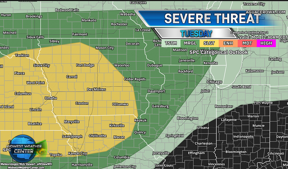
Officially, the Storm Precition Center has a Marginal Risk for the Quad Cities region including eastern Iowa and northern Illinois with a Slight Risk, a Level 2 of 5 Risk, tothe west. I like the trend here with SPC's outlooks and I think it looks pretty fair. Depending how much the morning showers and storms impact the environment that Slight Risk (yellow) region may need to be pushed even more west and south. Watching that potential closely.

Despite the limited severe potential, heavy rain is still possible. Latest guidance indicates 0.50" to 1.50" of rainfall across Iowa, however it will likely be more scattered instead of widespread. Guidance also has limited raincall towards the Quad Cities and northern Illinois with rainfall dissipating by the time it reaches the Mississippi River.

Looking beyond Tuesday, Friday appears to be the next best chance for widespread rainfall in the region. The European Ensemble has a pretty strong wet signal locally as another cold front is forecast to move through the region. Behind this it looks cooler and drier headed into the weekend.

The model blend is ptetty stafnant with temperatures over the next 10 days across the area with mid/upper 70s showing up late week into the weekend behind our upcoming cold fronts.

Looking longer term, trends are also indicating some potentially below-normal precipitation patterns heading into late August giving us some time to dry out. It's not a strong signal, only about 40-50% chance, but this is the first time I have really seen drier than normal conditions show up in the analogs in quite some time. Certainly something to watch.
-Meteorologist Nick Stewart


La publicación presenta la información de manera limpia y comprensible. Los datos relevantes pueden localizarse con facilidad y la explicación mantiene un tono natural. Como referencia final, loteria nacional queda integrada con el tema sin que el comentario resulte forzado o excesivamente repetitivo.