
A DECEMBER TO REMEMBER?
The last few Decembers haven't been much to write home about. On the whole, recent ones have been relatively mild and short on snow. Not like the ones I remember as a youngster in the 60s. Back then, even if we didn't have a lot of snow, we at least had cold. Maybe It's just my age, but the good old days seemed just a little bit tougher. One fact that stands out the past decade or so is we rarely see a white Christmas. In the Quad Cities, only 3 of the last 14 Christmas days


MENTAL TOUGHNESS
I haven't seen the sun all week long, and chances are it won't be with us again Friday. A stagnant weather pattern remains entrenched that's trapping low level moisture, converting it to clouds. I'm seeing signs we should get some breaks for sunshine over the weekend, but Friday brings the need for more mental toughness as we deal with one more dark dreary day, and one that starts with patchy fog and drizzle. Be strong, it's a Friday. If there is one bit of positive news to p


DARK DAYS...
With Thanksgiving just a week away, we've entered the time of year when the shadows are long and the days are short. Throw some clouds and drizzle into the mix, and it can be exceedingly dreary. It's what I call the dark days, the period where fall is about to transition into winter. It's not really cold, but far from warm and the clouds hang low as if to say, there's a lot worse where this came from, and you know it. Thursday will be the 4th day stuck in the muck, thanks to


IT SCREAMS WINTER...
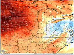
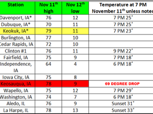
Significant changes are taking place that will result in a pattern realignment in roughly a week. This will bring significantly colder temperatures and set the stage for what should be a wintry start to December. More on today's developments in just a moment. First, Steve Gottschalk, the Lowden climate guru, continues his reports on extreme November weather events. This one is a humdinger that involves all types of impactful weather and left the Midwest dazed and confused. He


THE MARCH TOWARD CHANGE
A weather disturbance ejecting out of the southwest has brought showers to the region that will linger into Tuesday morning before tapering to drizzle and low clouds Tuesday afternoon. The dismal conditions will also be accompanied by chilly raw temperatures, which should range from 41 north to 46 north of I-80 to 46-51 south. Not one of our better efforts this fall. The upper air disturbance is not especially strong (and in a weakening state), even so a nice wing of warm air


