SEPTEMBER IN JULY....
- terryswails1
- Jul 23, 2018
- 2 min read
Are you ready for a little taste of Fall? Ready or not, it's coming. Here's what the Euro is showing for temperatures the next 10 days here in Cedar Rapids. It's got 5 consecutive days in the 70s which is far more typical of September than July

In fact, the projected high of 71 this Saturday in Cedar Rapids would be the average high September 24th.

If you think that's nice and fresh, check out the lows forecast August 2nd. Lots and lots of 40s from eastern Minnesota and Iowa into NW Illinois and Wisconsin. Those readings in the low 40s would be more typical of early October. The 43 in Dubuque would be representative of October 6th.

Here's a tighter view of the region. The Minimum in the eastern U.P. of Michigan reaches 38!

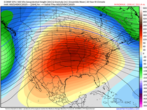
So what in the wide world is going on to thwart the dog days of summer? Simply, it's an anomalous change in the jet stream to northwest flow. Here's the 500mb jet today. One deep trough is departing the Midwest.

Here's July 31st. A new trough with fresh cool air is is digging into the central U.S.

Here's the breakdown of temperature departures the next 15 days in 5 day increments.
Days 0-5:

Days 5-10:

Days 10-15:

And just for kicks, here's the next 45 days ending September 6th. Cool is the rule!

Precipitation is a bit harder to predict, especially beyond 7 days in a pattern like this. Rainfall events are usually short in duration and scattered in coverage. Much like clipper systems in the winter, precipitation occurs in narrow bands. It's often hit and miss. With the Gulf of Mexico moisture supply largely cut-off I would expect below normal amounts in most area the next couple of weeks. That's pretty much what the EURO EPS ensembles are showing in my area with 1-1.5" totals. Typical amounts would be on the order of 2 to 2.5".

Cool, calm, and collected, that's the way I see it going forward. Nothing wrong with that, especially in mid-summer. Roll weather...TS


Comments