


BITS AND PIECES OF WINTER....
Most of September (especially the past 2 weeks) temperatures in SW Canada have been exceptionally cold. Just look at the departures since September 11th. That's a huge area of chill that's resulted in some record early season snows near Edmonton.

Speaking of snow, here's the areas covered in white gold as of the 25th of September.

That may not seem like much but but that part of Canada typically does not have snow cover this early in the season. See the departures below.

The past week both the GFS and the EURO have been showing the reservoir of Canadian cold entering the Midwest in a big way. Just a couple days ago the Climate Prediction Center had this for its 8-14 day outlook.
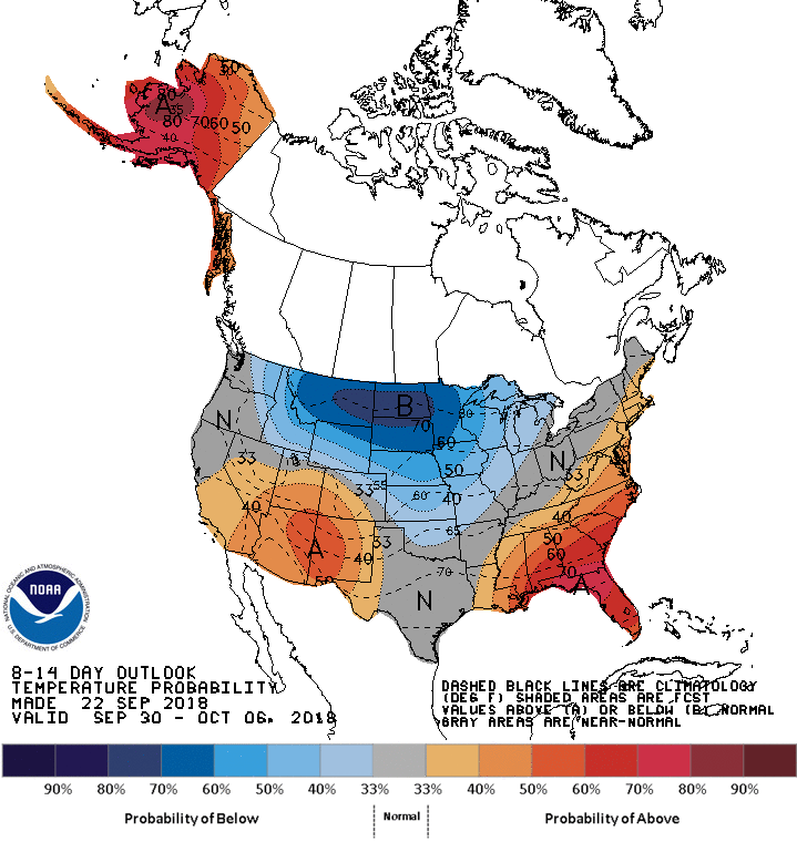
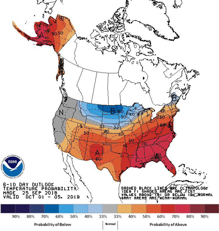
Today it's flipped showing showing above normal temperatures over the central Midwest instead of below. Much less of a southward push by the cold.
This has been frustrating. About the time I'm ready to jump on the trend to colder weather, new runs come in that back off or delay its arrival a few days. This has been going in for a good week and I've been wondering what's been giving the models fits? I've come to the conclusion that the MJO (Madden Julien Oscillation) is driving the pattern. If it was in a cold phase the Midwest would be a sitting duck for a healthy taste of November weather.
As it is the MJO is headed into phases 8 and 1 going into early October. You can see in the analogs below, (top left) phase 8 in October is tied to near or above normal temperatures in October.

Phase 1, which the MJO eventually cycles into is an even warmer signal. Look at the phase correlation associated with phase 1. Warmth over much of the U.S. east of the Rockies.

Because the MJO is in what would be considered warm phases does not mean we won't experience bouts of cool weather. That is coming for a couple days to start the weekend, especially with so much available up north. What it does mean is that it is much harder to get the motherload to invade the Midwest until we enter a different phase or something significant develops to off-set the MJO.
One of those things that can turn the tide against the MJO is a super typhoon like Trami which is set to make the turn northeast passing over Japan. From there it finds its way to the Bearing Sea. The remnants are likely to buckle the jet over western Canada increasing the chances of a deeper push of cold air into the Midwest within 10 days. However, even if we get a good shot of cold it's not likely to hit and hold with the MJO in phases 8 or 1. More likely it would be a quick in and out.

Getting back to the MJO, both phases 1 and 8 in October are generous Midwest precipitation producers. For that reason I look for our wet weather pattern to continue going forward. The GFS is seeing that with a 16 day precipitation forecast that looks like this.

Some of it's snow up north.

One thing is for sure, there's a lot going on in the North American weather pattern that's going to create forecast challenges. As for Wednesday, it will be a quiet day as sunshine and cooler temperatures dominate the scene. Until next time, roll weather...TS


