A PLATE FULL OF WEATHER...
- terryswails1
- Sep 5, 2020
- 4 min read
Make no mistake about it the Midwest is going to be a glutton when it comes to weather the next 7 days. There's so much on the table it's tough to chose where to start. When that happens, the old stand by is the beginning so here we go.
THE WEEKEND
This period is dominated by warm temperatures and the threat of scattered thunderstorms late Saturday night and early Sunday as an MCS rides a boundary southeast into Minnesota and northern Iowa. The southern extent of the precipitation shield is in question but my northern counties are most favored, especially north of HWY 30. The GFS is the most bullish showing these totals.

The 3k NAM has a similar look.

The EURO is a bit further north with the complex but has made a correction south since its previous run. We should have a much better feel for final placement later Saturday. Here's the EURO's rainfall forecast.

SPC shows the possibility of a few strong to severe storms Saturday night but that late night arrival should keep those minimal and more to the northwest where initiation takes place.

Whatever happens, storms will dissipate or move southeast by afternoon leaving outflow boundaries for new storm development late in the day. With highs near 90 there will be the potential of some hefty instability in the form of CAPE. The 3k NAM shows a ripe environment towards Sunday evening.

If the cap can break ahead of an advancing cold front severe storms could erupt Sunday evening. Best chances appear to be over the SE half of the area, especially southeast of a line from Cedar Rapids to Dubuque. SPC has the area highlighted for strong storm potential. Something to pay attention to in later forecasts.

THE CHANGE OF SEASONS
That brings us to Monday and the long advertised change of seasons tied to a strong cold front. If the timing holds the front should be through all of my area by daybreak Monday. Labor day skies should be mostly cloudy but rain chances should hold off until late in the day. With brisk east winds developing temperatures won't go up much from overnight lows. A big range in highs is likely from north to south on the order of the low 60s to low 80s. The EURO shows this.

The GFS is even cooler with highs that look more like this.

Monday night and Tuesday the front over Missouri comes to a halt and a long duration period of over-running along it takes shape. That means rain and unseasonably cool temperatures.
TALKING TEMPERATURES
On the topic of temperatures there is better agreement now that next week will take a chilly turn. After highs near 90 Sunday most models are in pretty solid agreement that Tuesday and Wednesday will be spent in the low 50s. The GFS is even worse showing 40s for highs. For that to happen we would need a steady rain which that model shows. I can't rule it out but 40s are hard to do September 8th! Get a load of the temperature departures on the GFS at mid-day Tuesday.

Wednesday is not much better.

You can see in the two temperature departure graphics a sharp thermal gradient. Along that the fight is on with cold vs. warm. That is the set up for rain, and perhaps plenty.
SWEET RAIN
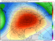
It's a well known fact much of the central Midwest is in need of rain and this is the type of set up that bring a good soaking rain that falls on and off for a number of days. A moist conveyor belt will be in place with prolonged forcing associated with a closed low that only slowly rotates across the lower Midwest. It looks like this at 500mb.

This is exactly the type of system necessary for putting a dent in a drought. From Saturday night through next Friday there will be daily chances of rain. Look what both the EURO and GFS produce in the rainfall department over that period.
The EURO

The GFS

SNOW IN IOWA?
Switching gears from summer to winter, that four letter word snow has also crept into the picture for some. While I think the chances for flakes are very low and limited to NW or NC Iowa, the EURO actually shows enough to measure, especially around Mason City. It wouldn't amount to much or be around more than a heartbeat but it would be one of the all-time earliest snows in the state if it happens. Things would have to come together just right and if I had to put odds on it I would say no more than 5 percent. Take a look at that little band from WC into NC Iowa. That's a sight for my sore eyes!

DIGGING DENVER
Where it will snow and stick is over the central high Plains and Rockies. Parts of the Denver metro could see up to 10" of very heavy wet snow. Digging in Denver is quite likely.

Even more amazing is the change in temperatures in Denver where they go from a high of 99 Sunday to a low of 20 by daybreak Wednesday. Nothing like an 80 degree drop in temperatures to get your blood flowing! Dang.

As you can see, the table is loaded, just the kind of feast this beast likes! Roll weather...TS


Comments