


IT'S ALWAYS SOMETHING...
- Jul 16, 2022
- 4 min read
For the last six weeks I've been working on my backyard at my new place in Dubuque. I cleared a bunch of trees, built a retaining wall, filled it with rock since I was reclaiming part of a ravine, then added top soil and grass seed. The project was just finished Tuesday. Here's what it looked like before the work began. Trees everywhere. From the house you could barely see the Mississippi below.

After all was said and done, I had a fantastic view, a nice big yard, and where I seeded earlier on the left side, grass was coming in nicely.

Here's a nighttime shot from my deck. The sunsets are incredible and lightning shows are worth paying for.

Then came Friday morning. 4.4 inches of rain in a short time wiped out the right half of the yard where it had just been seeded. The yard was all the way up to the top of the ties (see 2nd image above). In some places I lost more that a foot of fill and top soil. All I could do was sit on the deck and watch it go. Not the way to start the day.

Anyway, that was part of the big MCS that as expected, drenched the northeast half of my area. Here's the Doppler estimates showing the 3-5" swath in my northern counties.

Here's a closer perspective.

Saturday should be less active but there will be plenty of residual low level moisture producing clouds and perhaps some morning ground fog, especially in the north. With a weak disturbance passing through later in the day we may struggle to see much in the way of sunshine. Additionally, some isolated light showers may briefly pop up during the peak heating of the afternoon. These are likely to be light and widely scattered. Many spots should avoid them altogether. In the far south, highs could sneak into the upper 80s if there's enough sunshine. Otherwise the rest of the region enjoys low to mid 80s with considerable cloudiness.
Saturday night a wave moving along a stationary boundary in Missouri may ignite a few showers and storms for the area south of HWY 34. The worst of this should remain in Missouri and central Illinois. Here's what the 3k NAM shows for rainfall both Saturday and Saturday night.

Sunday should see sunshine emerge as the day unfolds. An isolated shower or two is possible but those should be few and far between (also light). Highs again will generally range from the low to mid 80s.
HOTTER TIMES AHEAD:
Next week will have it's challenges, most of them associated with a building heat dome. Monday an initial surge of warm muggy air enters on southerly winds. Highs will likely hit the upper 80s, perhaps 90 in the south. Tuesday the heat increases ahead of a seasonally strong cold front approaching from the northwest. With a stiff south wind, highs should reach 90 and may go as high as 95 in far southeast Iowa. With dew points in the 70s, heat index's of 95 to 100 are on the table. NBM highs are currently looking like this.

Tuesday night the cold front passes bringing with it a brief change to cooler and less humid conditions Wednesday and Thursday. The wild card is whether thunderstorms accompany the front. A healthy cap (warm air aloft) will be in place that may restrict storm development. However, the pre-frontal air mass will be unstable with CAPE of 3,000 j/kg already showing up in the early guidance.

If forcing is strong enough to break the cap, strong but progressive storms are possible in the evening. In it's current day 5 outlook the Storm Prediction Center is already a slight risk threat, mainly for strong winds. That's quite early in the game to show the 15% contour. Something to watch.

TO SIMMER OR SEAR, THAT IS THE QUESTION?
After the cool down Wednesday and Thursday, models are once again trying to expand the heat dome into the central U.S. The GFS in particular is showing extreme levels of searing heat. I honestly don't know what's gotten into the physics of the model but it shows max temperatures that are at all-time levels and I just can't buy what it's selling. Just for the purpose of showing you what I'm looking at, I'll put out its unrealistic numbers with the qualifier...THIS IS EXTREMELY UNLIKELY. I've never seen such blistering numbers in all my decades of doing weather. Here's the GFS meteograms starting with Des Moines, Cedar Rapids, and ending with Davenport.
Des Moines

Cedar Rapids

Davenport

To make my case of how far from reality the GFS is, here's what the EURO shows for Davenport. Compare that to what the GFS is suggesting for DVN above. Only 1 day through July 25 does it show a temperature higher than 100. None of those mythical 108-110 degree days.

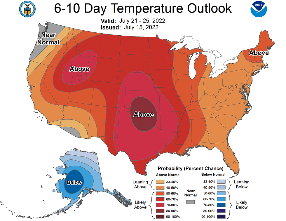
Discounting the GFS, the EURO is still indicating a very steamy warm-up over the Midwest July 22-26th and that seems plausible to me, especially considering the Climate Prediction Center shows a moderate risk of excessive heat in the July 23rd-29th period. I will be monitoring trends closely going forward.

Just to confirm, I do think we will get into some toasty mid summer heat during that July 21-26th stretch, that's supported by the CPC outlook over that period. Strictly speaking, if we do get into some serious heat, mid July is climatologically the time of year when odds are highest. We shall see.
On that note, I will end this thing and get to the tending of my backyard. I'm thinking of holding an impromptu mud wrestling event this weekend. I've got plenty of that to go around. Make lemonade out of lemons right! Roll weather...TS


Comments