PUMPKIN SPICE ON ICE....
- rebeccakopelman
- Oct 16, 2022
- 1 min read
Well you might want to make that a hot pumpkin spice latte with the big chill on the way. A big, strong high pressure system will be moving in to start the week:

The air tied with this high pressure can be traced back to the Arctic Circle/Russia:

It will start Monday morning with temperatures down below the freezing mark:

High temperatures Monday afternoon will just barely make it above 40 degrees... well below normal:

It will be sunny, but breezy. That will lead to wind chills (what it actually feels like) in the low 30s:

With mostly clear skies and this cold air in place, temperatures will drop like a rock into Tuesday morning:

Wind chills will be nearing the single digits with wind gusts up around 20-25 mph:

wWe'll have plenty of sunshine and still breezy conditions Tuesday. Temperatures remain below normal once again:

Wind chills will be about ten degrees lower than the actual temperature:

This cold air will be in place through the first half of the week:

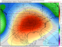
A big ridge of high pressure will build in and lead to warmer air by the end of the week and weekend:

Stay warm!
RK


Comments