


SPRING ABDUCTION (APB)
- Apr 27, 2023
- 4 min read
ALL POINTS BULLETIN FOR LOST SPRING

The meteorological community has issued an all points bulletin for spring!!! She was last seen April 15th at the conclusion of a warm spell that included several days in the 80s. Spring is pretty, filled with sunshine and highs in the 70s. If you see her, please report the good news to your closest weather authority and tell her to come home. She is greatly missed!
Please excuse my attempt at humor, it's the only way I can get through looking at these miserable weather charts which tell me, we are going to be on the cold side of mother nature for the better part of the next 10 days. It appeared that we had cracked the nut back in early April with an amazing stretch of weather that featured at least 3 (in many cases 4) consecutive days of 80 degree highs. Here in Dubuque we even tied the record high for April 12th with a high of 82. After that, spring slipped away.
Below you can see 11 of the first 15 days of April in Dubuque featured highs that were at least 62 or higher. Since then 10 of the last 11 days highs have been in the 40s and 50s. A disturbing trend that looks to remain in place for some time after a brief warm-up Thursday and Friday.

This graphic shows the daily high temperature departures in Dubuque ranging from as much as 26 above normal to 18 below. I also highlighted with a star the days where at least a trace of snow was reported. 5 days have seen snowflakes, 4 of those have come after April 15th. All told, 2.4 inches of snow has been measured.

I hate to say it but we may not be done with snowflakes yet as the GFS drives another very cold air mass into the region to close out the weekend. The GFS is showing snow showers with it (especially in the north) Sunday.

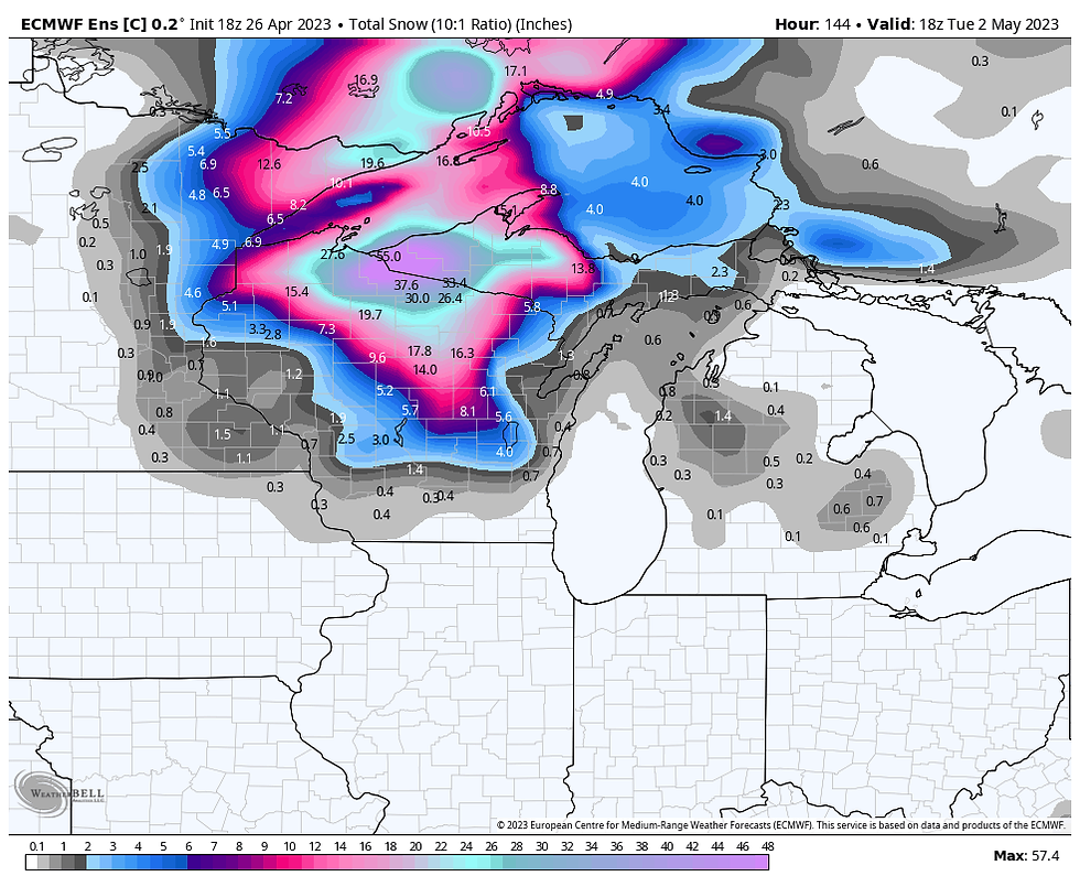
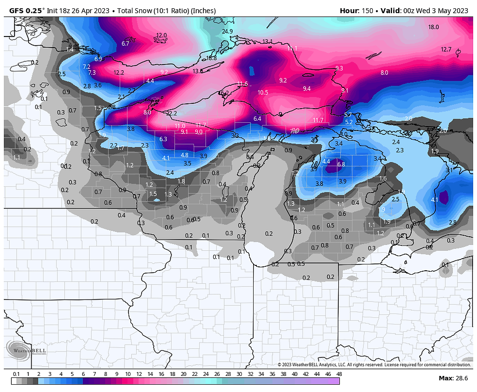
With temperatures -5 to -6C Sunday morning at 850mb (5,000 ft.), temperatures would be cold enough to support some wet snow getting to the ground even with temperatures of 35-40. It's a marginal situation but here's what the EURO and GFS are suggesting for snowfall. The best chance for seeing flakes in my area occurs during the period Sunday- Monday morning, especially north of HWY 30.
The EURO
The GFS
ONE HECK OF A DEAL 3 NIGHTS FOR THE PRICE OF 2 MEMORIAL WEEKEND AT MY CHURCH IN GALENA

THE LITTLE WHITE CHURCH AWAITS YOU
Get the gang together. Kick off summer with a free night at the church, one of the most unique stays in the Midwest. Call Carolyn at 563-676-3320 or email carolynswettstone@yahoo.com CLICK HERE
MORE ON THE CHILL...
The very cold temperatures aloft will also provide plenty of instability for clouds, gusty winds, and scattered light showers. These are likely to be random (hit and miss) in nature. However, with vorticity wrapping around the upper air low there may be a couple periods where forcing is more focused implying greater coverage of showers, whether they be rain or snow. These mesoscale details are hard to see at this distance but common in this type of scenario.
Notice too the tight packing of the isobars between high pressure to the west and low pressure out east. That will whip up strong winds of 35-40 mph that drive the cold air into the Midwest Saturday night and Sunday.

By Monday the EURO indicates highs only in the low to mid 40s in all but the far south.
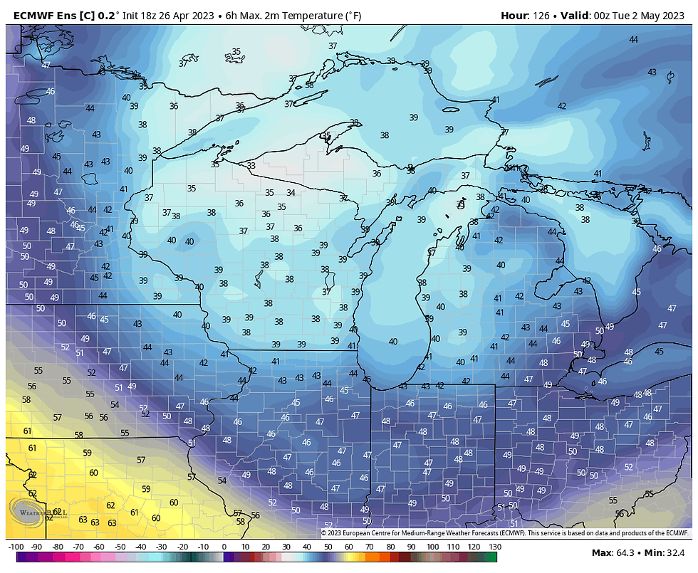
Readings such as that are about 19-23 degrees below normal.

Wind chills Monday morning are in the 20s north to low 30s south.

Here's the powerful closed upper air circulation that pinwheels over the Great Lakes like a top for several days. Cut-off from the westerlies it feeds on itself and the cold air at its center. That's a formidable system.

The vortex finally weakens midweek only to be quickly followed by another surge of cold air that elongates the trough. Ahead of it we will likely see a brief warm-up before the next round of chilly air. You can see the blocking over the top in reds that is promoting high pressure in Canada. That forces the anomalously cold air south into the eastern half of the nation.

For this to all end we must get rid of the blocking at high latitudes, especially over Greenland. The EURO implies that happening by May 10th with its MJO advancing from phase 1 where it is located now to phase 6 May 10th. The phase 6 analogs correlate to warm wet weather in May. That would be a significant pattern change.
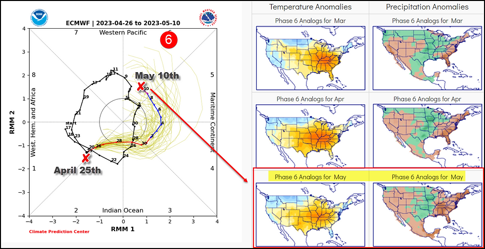
The 500mb flow on the EURO control the morning of May 11th shows the blocking in Canada diminished and the eastern trough breaking down and lifting out. That's consistent with what the MJO is signaling.

The day 15 temperature departures May 11th show warmth in the Plains building east toward the Midwest. I am optimistic we can finish the transition in the following days.

There's a lot of fascinating things going on weatherwise right now if you are into it like me. I should also mention that we have a couple pretty good days to enjoy before the party ends this weekend. I am looking forward to that. That's all for now. If you see spring, tell her it's time for her to come home! Roll weather...TS
A MESSAGE: Voluntary donations from people like you support the content, infrastructure, and operational cost of this site. Your contribution however small, makes a big difference. Please consider a donation, and thanks to the 416 of you who have answered the call. It is greatly appreciated. Just click the banner to make a voluntary donation. TS


Comments