THE CLOCK IS TICKING...
- Nov 6, 2021
- 4 min read
A BRAVE FORECASTER...

BE A FUNDRAISING WARRIOR... We are up to 296 of you who have made a voluntary $12 dollar donation to TSwails.com. I still need the support of 104 more of you to keep things going. Thanks to your generous donations to date, we are on our way and with a little more help we'll achieve our goal. All I'm asking is that if you enjoy the site and see value in it, please consider a voluntary subscription. I'm asking $12.00 dollars for a year. That's $1 dollar a month or 3 cents a blog if you consider the fact there were 450 posts issued over the past year. The site requires a significant commitment of time and resources and every donation, whatever the size is deeply appreciated. I just need a little help to cover the expenses. Click on the link below if you can assist or or need additional information. I thank you for your support and consideration.
INDIAN SUMMER WEEKEND....
Thanks to some early November sunshine temperatures warmed into the range of 50-55 degrees Friday afternoon. I took a walk with Nimbus the weather dog and quickly realized I was over-dressed. After unzipping the coat I finally just took it off an carried it.
With temperatures continuing to rise into the 60s into Monday, we are now getting our first taste of Indian summer. You may hear the term used to refer to any period of unseasonably warm weather in autumn, but traditionally, “Indian summer” refers to something more specific. Here's the criteria for true Indian summer:
As well as being warm, the atmosphere during Indian summer is hazy or smoky, there is little wind, the barometer is standing high, and the nights are clear and chilly.
A moving, cool, shallow polar air mass is converting into a deep, warm, stagnant anticyclone (high pressure) system, which has the effect of causing the haze and large swing in temperature between day and night.
The time of occurrence is important: The warm days must follow a spell of cold weather or a good hard frost, but also be before first snowfall.
The conditions described above also must occur between St. Martin’s Day (November 11) and November 20. For over 200 years, The Old Farmer’s Almanac has adhered to the saying, “If All Saints’ (November 1) brings out winter, St. Martin’s brings out Indian summer.”

The weather we'll experience this weekend fits the criteria to a T. satisfying most of the criteria. So where does the term originate. To be honest, nobody knows for sure. The Farmer's Almanac states several potential sources.
Some say the term comes from the Algonquian people located in what is now the northeastern United States, who believed that the condition was caused by a warm wind sent from the court of their southwestern god, Cautantowwit (“great spirit”).

Similarly, another origin states that Native Americans would routinely use this brief period of warm fall weather to gather a final round of supplies before winter’s hold set in. November is the time to get one’s last harvest in before winter truly shows its head, so a short period of warm weather would be of note around this time.
Yet another claim involves European settlers in New England. Each year, they would welcome the arrival of cold, wintry weather in late October when they could leave their stockades unarmed. But then came a time when it would suddenly turn warm again, and the Native Americans would decide to have one more go at the settlers. “Indian summer,” the settlers called it.
Wherever it came from, the term Indian summer implies nice weather and that's what's on the table throughout the Midwest through Monday. The EURO shows this for highs in Cedar Rapids Saturday-Monday.

After a straight forward and trouble free forecast through Monday, issues begin to show as early as Tuesday. That's when the Pacific wave train starts dumping energy into the west that carves out a deep Midwest trough towards the middle of next week. Ahead of the main short wave, a weak disturbance could kick up a few showers Tuesday. Dry air will be a limiting factor and rain amounts should be light. Highs will probably cool a bit Tuesday and Wednesday but how much depends on clouds, precipitation, and how far SE the cold front gets. The GFS keeps readings in the 60s both days, The EURO is considerably cooler with highs in the 50s.
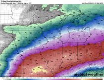
The problem stems from the amount of phasing between the northern and southern branches of the jet. Not only does that impact temperatures, it dictates intensity, track, and precipitation. Essentially just about every aspect of our weather is altered and until this issue is resolved confidence remains low regarding the evolution of the primary energy Thursday. Both the EURO and GFS have converged on developing a closed upper air low in Minnesota with the latest runs showing a pre-frontal band of showers (maybe a thunderstorm) passing through the area Thursday. The track of the surface low and the timing of the forcing will determine where the heavier rain totals occur. The EURO shows this through Friday.

The GFS indicates this.

Still plenty of time to get this resolved but I suspect it may take until Sunday or Monday before the real truth is revealed. One message does come through loud and clear and that is much colder temperatures will follow the system next weekend. These are the temperature departures the GFS shows Saturday following the storm. A pretty healthy cool-down.

That's all for this addition. Enjoy the fine fall weather ahead, the clock is ticking! Thanks for your time and if you appreciate the site please consider a donation by clicking the link below. The future of TSwails is in your kind and caring hands. Roll weather...TS


Comments