


WHAT'S NOT TO LIKE...
- Oct 21, 2022
- 4 min read
There's no shortage of good things to talk about in the weekend ahead. Not the least of which is highs reaching far into the 70s, levels that will be up to 55 degrees warmer than the lows we experienced Wednesday. I'll get to that in a minute but first wanted to touch on the growing dryness.
The latest drought monitor released Thursday shows another rain free week has increased dry soils even more across Iowa. 100 percent of the state is abnormally dry with 84 percent of the state in moderate to extreme drought. That's up from 57 percent last week. My area in eastern Iowa is in slightly better shape than NW or SC Iowa but even here, we are close to reaching moderate drought status.

Here's the Midwest as a whole and it's easy to see there is a lot of color indicating the spots where lack of recent rain has become an issue.

Compare where we are today to where we were at the end of June and you can see the damage done in the last 3 three months.

If the drought wasn't enough, extreme cold showed up well ahead of schedule. The low of 16 Wednesday morning (Oct. 19th) in Cedar Rapids crushed the record for the date and was the earliest for such a temperature by over a week. The chart below from the Iowa Mesonet, presents the seasonal combination of first date with a low temperature below 17 and the number of such dates for the season. A more typical date (in the middle of the scatter plot) would be more like November 15th. Last year Cedar Rapids did not reach lower than 17 until November 17th, and in 1923 didn't get there until December 31st!

The cold began making a hasty retreat Thursday thanks to the return of chinook like westerly winds. The temperature in the Quad Cities went from a low of 29 to an afternoon high of 69. Shenandoah, Iowa made a 45 degree jump going from 27 to 72. Talk about a step in the right direction.
As we enter the weekend, increasing southerly winds will generate strong warm air advection. Combined with very dry air it will create unusually warm temperatures. In fact, 850 readings at 5,000ft are projected to be in the 99th percentile of climatology. It's entirely possible that after highs in the low to mid 70s Friday, highs Saturday could reach 80 in my SW counties with mid to upper 70s expected in the NE. Sunday may see enough clouds and higher moisture levels to keep readings a few degrees cooler. However, that could be off-set by gusty SW winds of 35 mph so again, upper 70s to near 80 looks to be a good bet.
The warm gusty winds and dry conditions will also create a very high wild fire danger. Burning is not advised, especially Saturday and Sunday. Here's the temperature departures for both Saturday and Sunday. Wow, what a reversal from where we were mid-week.
Saturday
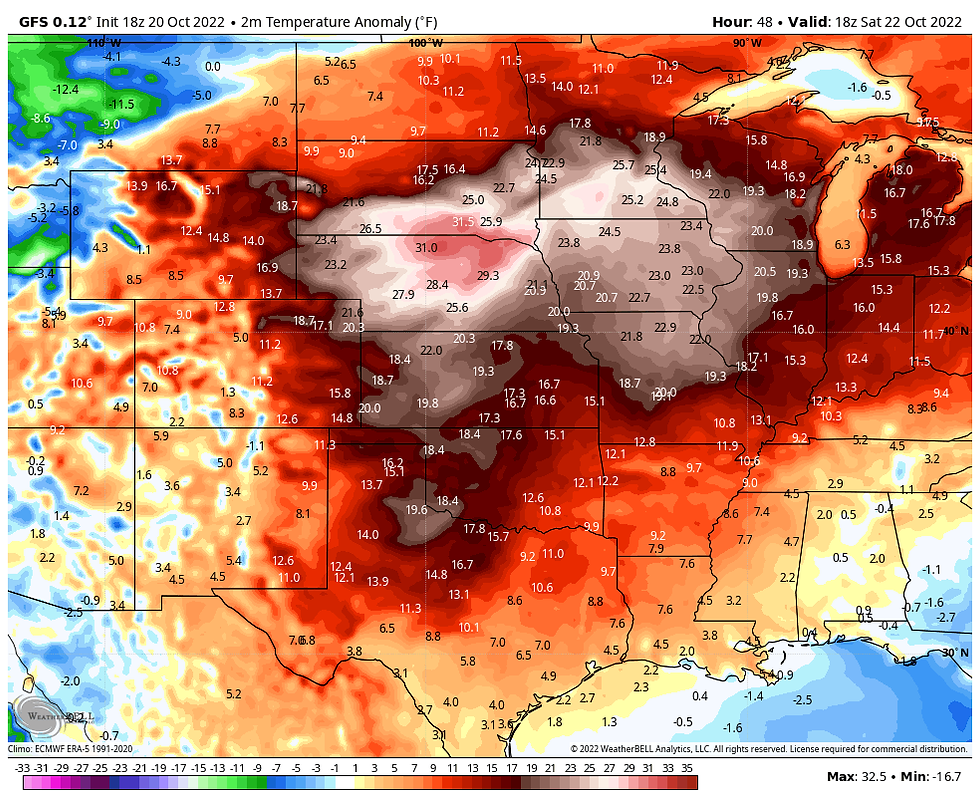
Sunday

HOW ABOUT SOME RAIN
Rain chances remain non-existent through Saturday and most likely much of the day Sunday. However, by Sunday evening prospects begin to show up. However, the best opportunity for rain is now expected to hold off until late Monday and in particular Tuesday. Some significant changes have shown up in modeling tied to phasing to create this trend. When I refer to phasing, I'm talking about the interaction of the polar and sub-tropical jets. Instead of one fully phased jet, we now expect two distinct pieces of energy, one in each individual branch. These arrive at different times and thus the two windows for rain I mentioned above.
The first opportunity Sunday evening is tied to energy in the northern stream which carves out a deep trough and a resultant strong surface low. This enhances water vapor transport late Sunday that leads to instability. As the surface low races northeast Sunday night it will draw some vorticity and enough lift into the region for widely scattered showers and thunderstorms. The best chance of seeing this will be in the NW half of my area. This is not the main show and the fast movement of this system will preclude much in the way rainfall.
Meantime as the northern branch energy exits, the southern stream energy is emerging out of the southern Plains Monday. My area should be in-between systems and without much forcing I look for a relatively quiet day Monday. Readings remain mild but will be slightly cooler as a a cold front drifts southeast through the region. Monday night the southern stream energy rides northeast along the stalled front. With a a good period of lift and better moisture in place, this is the money maker. If we are going to get beneficial rain, this is the system that will do it.
As much as I would like to say it's a go for a nice rain, there remains differences in track between the EURO and GFS. They both have the same idea but disagree on the path. The GFS is a bit more phased and further NW, it's the wettest solution for my area. Here's what the GFS depicts for rain from what falls Sunday night (very little if any) and what the second system drums up Tuesday.
The GFS

The EURO with its more southeasterly track keeps the heavier axis further east.

The national blend of models splits the difference and covers all of my area in a welcome rain. I am hoping this is the solution that verifies.

This will not be the last chance for rain as the pattern is loaded with energy and several more vigorous disturbances are indicated in the next couple of weeks. This GFS animation shows them rolling across North America ending November 5th.

Look at the above normal precipitation shown over that period by way of the 16 day GFS anomalies.

These are the actual totals ending November 5th.

Things are starting to click in the weather world as the seasonal changes are strengthening the jet stream and the short wave energy within it. Let the fun begin. Happy Friday and roll weather...TS


Comments